5 Ways the Geographic Approach Transforms County Planning
Upcoming Events
Related News

It’s no secret that geography is a key factor in all things related to planning and community development. Sometimes it’s an influencing factor. Sometimes it’s the main driver for a project and the reason why the public embraces or opposes it. A Geographic information system (GIS) is the tool that helps us measure, analyze, and visualize geography. For many of its early years, GIS was out of reach to many planning professionals, because it required expensive hardware, client-side software, and usually multiple weeks of training. It was an investment many planners couldn’t make, particularly if they had access to a GIS professional in their organization. But when you have people who aren’t subject matter experts in planning involved in planning-focused analysis, it’s very easy for information to get lost in translation. The emergence of web-based GIS has since evolved the role of planners in being able to efficiently access and utilize tools that help them make better, more sustainable, data-driven decisions, while simultaneously freeing up GIS staff to work on other crucial projects. Below are the five steps that utilize a modern geographic approach to planning.
1) Understand Neighborhood Characteristics
TED Conference founder Richard Saul Wurman has an often-repeated quote, “A map is a pattern made understandable, and understanding precedes action.” GIS helps us understand the demographics, socio-economic characteristics, housing situation and more, about individual neighborhoods. Instead of relying on anecdotal and/or dated information, GIS provides access to thousands of authoritative variables to generate a clear picture about the aspects, resources, and needs of a community. Within the Esri platform, this is accomplished using ArcGIS Business Analyst Web App. This web-based approach provides an easy way to not only view and analyze the data, but collaborate with colleagues, property developers, elected officials, and the public, so that everyone is working off of the same authoritative content.
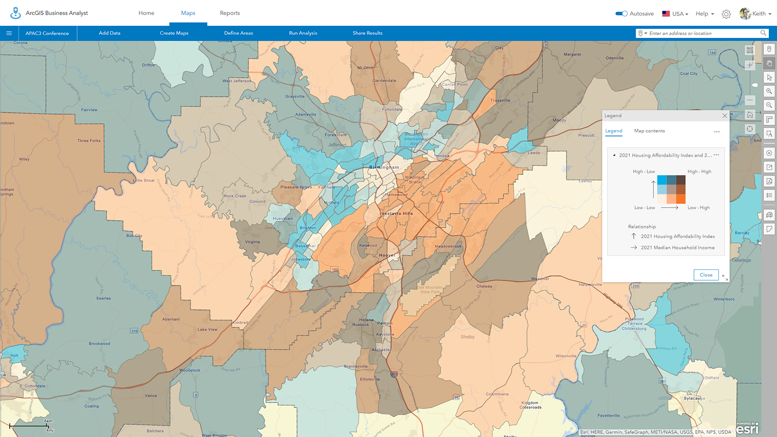
Map of Jefferson County, Alabama shows a correlation between housing affordability and median household income.
Two of the outputs within the app include infographics (both templated and customized) and reports. These provide valuable complements to the maps to help drive decisions about locating businesses, community needs, workforce information, spending behavior and more.
|
|
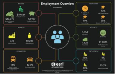
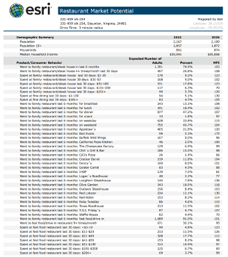
The infographic and report generated in ArcGIS Business Analyst Web App shows employment overview and restaurant market potential for a given neighborhood.
2) Derive Business Intelligence
The permitting system is almost always the system of record in a planning department. Usually, though, the data entry and analysis are done by a relatively small group within the organization. Despite that, there is useful information in the permitting system that can help decision makers. This can be even more challenging with a legacy system in place, which is not uncommon, given the cost of permitting systems. Planners, administrators, and elected officials need to be able to derive business intelligence (BI) from the permitting system. Within the Esri platform, this is done with a web-based app called ArcGIS Insights.
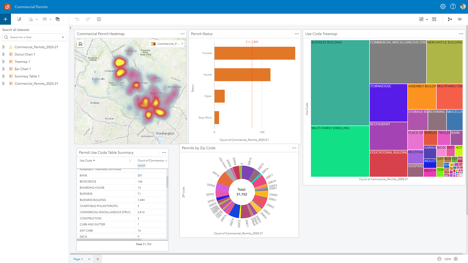
A workbook in ArcGIS Insights shows commercial permits since 2010. This content was populated with data from a spreadsheet found on the county’s open data page.
Even though the user is not a direct user of the permitting system, from a simple output from the system, they’re able to use GIS to answer questions like:
- How do the number of permits in my county this month/year compare to last month, last year, or five years ago?
- Where is most of the activity occurring? How do the developments in one council district compare to that of a neighboring district?
- What neighborhoods and what types of permits have received the most stop work orders?
In the end, this kind of BI helps efficiently generate more value from a permitting system that a community has likely already invested hundreds of thousands of dollars over the years.
3) Generate Sustainable Policies
We’re seeing the role of planners increase from traditional roles of simply reviewing site plans and subdivision plats. Planners are becoming much more influential in policy development for cities and counties, whether that’s found in a comprehensive plan, housing policy, or economic development (all of which are usually intertwined). Just like understanding neighborhood characteristics, policy development works best with a data-driven approach. A free resource called Esri Maps for Public Policy is dedicated to raising the level of spatial and data literacy used in public policy, from economic opportunity to social equity to transportation and infrastructure to public safety. The site provides curated maps to help county officials generate more sustainable and more justifiable policies.
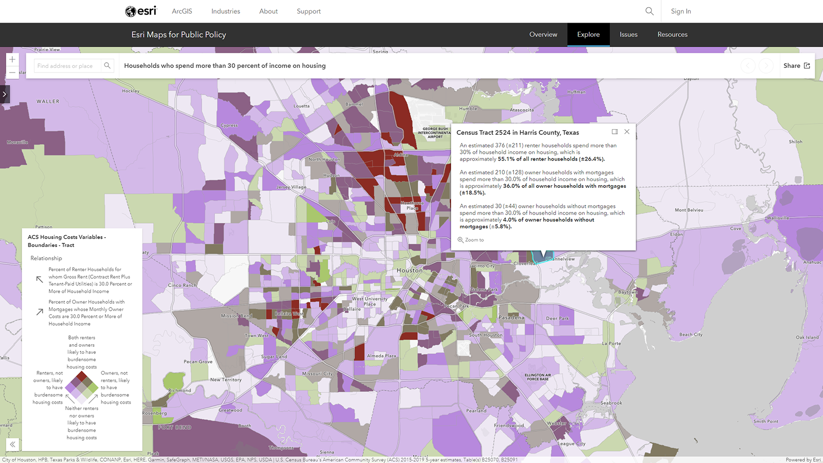
One of the maps available in Esri Maps for Public Policy shows households in Harris County, Texas spending more than 1/3 of their income on housing.
This content can exist on its own and can be simply viewed in a browser or collected and added to another app within the ArcGIS environment.
4) Support Civic Inclusion
Virtually everyone cares about their neighborhoods in which they live. In the past, when residents wanted to voice their concerns, their only outlet was a public hearing at a planning commission meeting or perhaps a less-frequent town hall meeting. But someone not being able to show up for the planning commission meeting on Tuesday at 7:00pm doesn’t equate to them not caring about their community. Community leaders have an obligation today to be more inclusive in finding ways for the public to engage (as well as be engaged by) their government. As stated before, location is at the heart of most of these projects, so GIS continues to remain a key component, even in civic inclusion. ArcGIS Hub provides a focused, initiative-driven approach to open data, as well as delivering information and receiving feedback. That feedback could be a survey, a freeform comment, or drawing an area on a map where they’d like to see a park built. What this kind of approach to civic inclusion helps to develop is less about simply public notification and more about developing a genuine partnership between the government and the public.
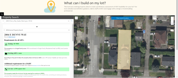
Seattle’s ADUniverse ArcGIS Hub page helps property owners discover what kind of accessory dwelling unit (ADU) they can build on their lot, as well as view and purchase pre-approved designs.
5) Design Sustainable Scenarios
With understanding, policy development, and civic inclusion in place, planners can more effectively design the types of plans and projects that meet the needs of the community. This can be done as a collaborative effort with developers or as a proactive way of demonstrating how a community’s needs can be met with a specific design or land use plan. ArcGIS Urban provides the 3D and 2D web-based tools for planners to quickly and efficiently develop multiple scenarios, view and measure the impact of their scenario (e.g. population, jobs, utilities, traffic, tax revenue, etc.), and compare the scenarios for review by administrators, developers, and the public. Zoning reform has become an emerging demand in many communities, particularly regarding meeting the modern housing needs of a community. ArcGIS Urban allows planners to play out and compare different zoning scenarios to show how many people and jobs could be accommodated with a new proposed zoning classification, without spending tens of thousands of dollars on consultants. It’s an effective way to streamline changes in dated codes that stifle the growth and development of neighborhoods.
|
|


Neighborhood redevelopment and specific project developments created in ArcGIS Urban. Each development has metrics and targets tied to it to ensure you’re creating what your community needs.
Because ArcGIS Urban is part of the overall platform, the 3D web scenes created from planning these scenarios can be shared with others and integrated into ArcGIS CityEngine to provide a photo-realistic view of a proposed development.
We’ve seen for years that GIS is no longer a luxury in county planning departments. It’s a mission-critical system. Now, the apps and tools it provides are more accessible to planning professionals than ever. The geographic approach to planning empowers data-driven decision making, policy development, and design that meets the modern needs of your county.
Post Sponsor


Counties and Railroads: Shared Priorities for the Next Surface Transportation Bill
County leaders from across the country have a vital opportunity to ensure their infrastructure priorities are front and center.

Unlocking AI Starts With Strong Data Governance
Strong data governance is the foundation of trustworthy AI in government. When Agencies inventory, clean, unify and steward their data, they unlock better decisions, improved services and stronger public trust.

How County Governments Thrive with Cloud-Based Solutions
Modern cloud infrastructure enables agencies to better meet residents and workforce needs. Agencies report increased efficiencies as well as reduction of technical and operational debt as they replace aging, fragmented systems.

The Cybersecurity Health Check List: Ensure Your Cybersecurity Program is Healthy and Resilient
Many organizations neglect their cybersecurity "health," leaving them vulnerable to sudden, catastrophic cyberattacks. By following a simple cybersecurity health checklist, you can ensure your organization's cybersecurity program is healthy and resilient.

APS Expands Heat Relief Efforts in Maricopa County, Arizona
APS supports and partners with community organizations and nonprofits to provide heat relief.

Prepared to respond: How counties can strengthen readiness amid federal emergency management policy changes
As local leaders, you are often the first call - and the final line of defense - when disaster strikes. From hurricanes and wildfires to floods and winter storms, natural disasters are growing in both frequency and intensity nationwide.

#LightAPath for Amazon Deliveries This Winter
During reduced daylight hours, Amazon is encouraging customers to help drivers when they are delivering their packages in the dark.

New in 2025: Counties Should Prepare Now for the Upcoming HIPAA Security Rule Update
Counties across the country are leveraging the Sectri platform to achieve HIPAA Security Rule compliance and to proactively prepare for the updated requirements set to be finalized in 2025.

America's Opioid Crisis: Counties as Frontline Forces in the Fight
Counties serve as the first line of defense, providing essential services in public health, mental health, law enforcement and social services - supporting communities in crisis and driving lasting recovery.

Empowering Communities: How County Leaders are Tackling the Opioid Crisis Head-On
Forward-thinking county leaders are implementing year-round strategies to prevent overdoses, educate communities about the importance of proper drug disposal and connect residents with local resources for support.

County collaboration is key to overcoming the cybersecurity talent shortage
In the United States, citizens depend on county governments to deliver many of the nation’s most critical services. These organizations play a crucial role in ensuring overall community well-being by managing essential services such as law enforcement, public health, infrastructure maintenance, and emergency response.

DTE Energy bringing natural gas, opportunity to Tri-County Region in Northern Michigan
Residents of Benzie, Manistee and Wexford counties in Michigan can breathe a sigh of relief this winter as natural gas becomes available in the region for the first time leading to significant savings, increased comfort and improved reliability.

Building Resilience Against Climate Change – Insights from Tidal Basin
Carlos J. Castillo, President of Federal Services at Tidal Basin, emphasized the critical role of emergency management in local climate resilience at the 2024 NACo Legislative Conference and Annual Conference.

Investing Over $100 Billion in American Infrastructure
AT&T has invested over $140 billion in the past five years to enhance American connectivity, focusing on expanding its role as the nation's largest fiber internet provider and improving its reliable 5G network, which now serves nearly 290 million people.

Building Networks for the Next Century, Not the Last One
AT&T emphasizes its nearly 150-year history of innovation and connectivity as it transitions from traditional copper landlines to modern fiber and wireless technologies, highlighting the importance of adapting to current consumer demands and technological advancements.

Travis County Develops 2,000 Units of Housing to Address Homelessness
This post is sponsored by our partners at Guidehouse. Through Guidehouse's comprehensive support, Travis County is on track to successfully create over 2,000 units of affordable, supportive housing by 2027.

Feeding kids during the summer requires county officials
The introduction of the Summer Electronic Benefit Transfer program marks a pivotal shift in addressing childhood hunger, especially during the summer when school meals are unavailable. This nationwide initiative, offering substantial grocery benefits, promises transformative support for over 29 million children, with a significant impact on communities facing systemic inequalities.

Why customer-centric strategy is vital for digital service adoption
The importance of a customer-centric strategy in digital service adoption for county governments is emphasized, highlighting the need for thoughtful design, clear communication, and multi-channel engagement to meet user expectations and improve customer experience.

Fighting opioid addiction – one life at a time
The opioid crisis, a major national issue, saw a 55% increase in drug overdose deaths from 2019 to 2022, with 75% involving opioids. Effective strategies to combat this include integrated care, policy enhancement, and technology, focusing on whole-person care and intervention opportunities to save lives.

Planning for the post-American Rescue Plan Act future
Guidehouse outlines strategies for state and local governments to sustain programs after the end of American Rescue Plan Act (ARPA) State and Local Fiscal Recovery Funds (SLFRF) funding. It emphasizes the need for reassessing constituent needs, measuring program impact, and considering fiscal implications to ensure long-term viability and effective resource allocation for programs initially funded by SLFRF.

How voluntary benefits can help improve your employee benefit package
Voluntary benefits, tailored to diverse employee needs and often at reduced costs, are proving essential in enhancing employer benefit packages, attracting, and retaining talent, and addressing specific wellbeing issues across different age and income groups.

A countywide opioid misuse prevention campaign is easier to implement than you think
The Deterra Household Mailing Campaign delivers educational tools and deactivation pouches directly to homes. To save lives by tackling the opioid crisis.

From prevention to resilience: Strategies in wildfire mitigation
Explore a multifaceted approach to wildfire mitigation with Tidal Basin. From creating defensible spaces to early detection systems, discover strategies fostering resilient communities, protecting lives & property. Urgent action is crucial amidst rising wildfire risks. Learn more at TidalBasinGroup.com.


Related News


Counties get creative with land use to add affordable housing
Orange County, Fla. is working to develop affordable housing on land owned by religious institutions and Fairfax County, Va. is exploring co-locating its libraries with affordable housing.

Senate begins reauthorization process for State Revolving Fund programs and other water infrastructure programs
On July 13, leaders of the U.S. Senate Environment and Public Works (EPW) Committee released the text of its Water Resources Development Act of 2026 (WRDA 2026). In addition to reauthorizing major projects through the U.S. Army of Corps of Engineers (Army Corps), the bipartisan legislation would reauthorize the Clean Water and Drinking Water State Revolving Fund (SRF) programs.