Four Rod Roads and GIS: Preparing for Infrastructure Funding
Upcoming Events
Related News

As a young surveyor in New England, it became rapidly evident how important a rod was. For those who haven’t been introduced to historic measurements in surveying – a rod is 16.5 feet and four rods make a chain (66 feet). Rods as measurements go back to nearly the beginning and the rod we know today dates at least to the Middle Ages.
But why is this important in right-of-way? In the early US days, town roads were usually three rods wide. County roads – roads that went from town to town, were usually four rods or 66 feet. You may have heard a road referred to a "three rod road" or "four rod road." So, in New England when you measure the width of a road from the maple trees or the stone walls that line the edge of a right-of-way, this measurement usually gives you a good indication of where to begin research on the record of the right-of-way. Counties need to know the size and location of their right-of-way to fit new and rebuilt infrastructure.
Right-of-Way – Critical to Infrastructure Development
Infrastructure development projects are complex with many stakeholders and a lot of moving parts. In the past, keeping everything organized and everyone informed was costly and time consuming. GIS delivers new capabilities to streamline the process, eliminate duplicated efforts, add new efficiencies, and deliver a framework for better decision making.
We often think of infrastructure as a lifecycle, which includes planning, surveying/data collection, analysis, design, construction, as-built, and operations. Right-of-way also has its own lifecycle running in conjunction with infrastructure development. These workflows are interdependent, so having good data management practices benefits the entire project. GIS enables sharing data from the infrastructure development lifecycle with the right-of-way lifecycle, delivering efficiencies from planning to construction. Importantly, GIS delivers efficient, operational capabilities to leverage data that is collected along both lifecycles.
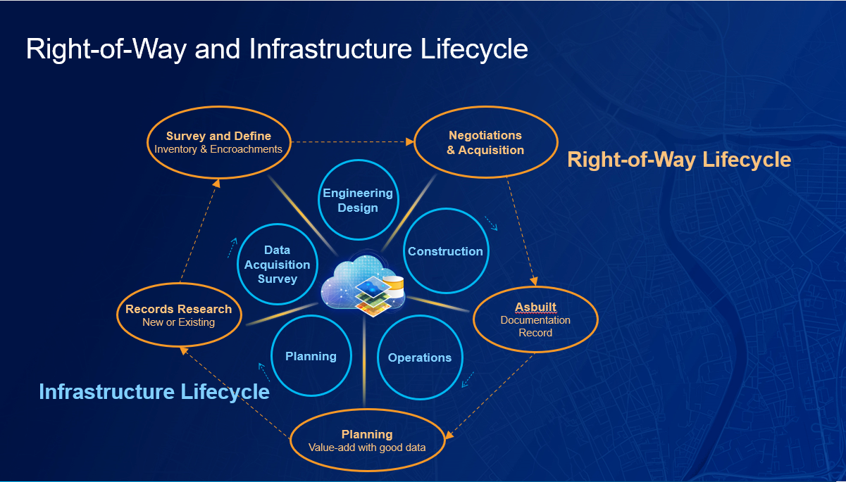
Figure A – GIS delivers value to the interdependent infrastructure and right-of-way lifecycles.
Managing an infrastructure or construction project is complicated. Part of that complication is because of the right-of-way. Where is the right-of-way? What is in the right-of-way? Who has rights in the right-of-way? Does our project fit in the right-of-way? How much does it cost to purchase additional right-of-way? Who owns the land? Are landowners supportive of our project? It’s complicated and it takes a lot of data in a holistic view to answer these and other questions. GIS provides projects with end-to-end, location-aware, project-tracking dashboards that deliver data across the project teams to help coordinate efforts and avoid excessive costs. Integrating construction management, permitting, inspection, and right-of-way status helps reduce risks and keeps projects on schedule.
Improve Planning – Working with Good Data Adds Value
It all begins with good data. Basemaps, such as satellite imagery, tax parcels, topography, existing utility networks, project files, environmental data, CAD, cultural data, existing right-of-way maps, and more are all integrated into GIS. Much of the planning data needed to begin a project is available in the Living Atlas as part of the geospatial infrastructure necessary for large projects. GIS delivers the data integration and data management requirements to visualize all data in a single view. Is this route feasible? What are the major project impediments with a particular alignment? Are there too many costly crossings? Should alternatives be considered?
When all available data is in GIS, alternatives are easily calculated and reviewed. GIS can optimize routes based on known conditions at the time. As new information is entered, new alternative routes can be calculated and analyzed. GIS helps you optimize new routes and communicate various scenarios with stakeholders and the public.
Enhance Data Acquisition, Records Research, Survey and Inventory
No two projects are the same, which also applies to what data is needed and where that data is. What tends to be an iterative process, GIS can make more efficient. GIS helps connect documents, deeds, contracts, field data, and field communications into a source of available information. Field work scheduling and reporting dashboards enable open communication with all data.
ArcGIS has configurable tools from field data collection and inventory to imagery collection and processing with drones. With smart phones and tablets, using configurable data collection applications can connect to high accuracy GNSS for precise mapping locations and can be easily set up to interview and collect landowner information. Because every project is different, the ability to easily configure tools for the project saves time, money, and eliminates duplicated field efforts.
Manage Negotiations and Real Estate Acquisition
Good public engagement is paramount for complex projects to succeed. Integrating the public record parcels and assessment data with project data helps property owners understand and negotiate right-of-way acquisition fairly. Developing and maintaining trust with landowners is critical to fair and equitable value. Delivering accurate, current project information creates transparency and fosters this relationship.
Right-of-ways cross many properties and involve many property owners. Engaging with landowners, local officials, and all stakeholders requires a two-way conversation. Using new, web-based engagement tools helps deliver current project information and enables stakeholders to subscribe to updates and provide input. Information hubs are an easy-to-configure cloud platform that organizes data and tools to accomplish specific project outreach and communication. Hubs are the center of all public outreach.
Enable Efficient Operations with Accurate As-built Data
As-built information, or the data related to what was actually constructed, is important for infrastructure management, but equally important for right-of-way information. Knowing who has what rights, how to access the right-of-way, maintenance requirements, and legal obligations among others, all benefit from well-managed information and good documentation. By laying the foundation for the future of new infrastructure that requires use of an existing right-of-way, efficiencies with planning, record research, surveying, and negotiations will benefit all.
Improve Your Right-of-Way Management with GIS
As we rethink, reimagine and rebuild our nation’s infrastructure, GIS is more important than ever. GIS plays a critical role in the entire infrastructure lifecycle from planning, surveying, design, construction, as-built documentation and ongoing operations and maintenance. This is also the case with right-of-way. GIS improves project planning by delivering integrated project and basemap data and information to all stakeholders. GIS adds new ways to collect, organize and manage ownership records, deeds, surveys, projects plans and more. GIS enables high-accuracy data collection reducing visits to the field. GIS reduces costs, strengthens public engagement and increases project efficiencies. GIS delivers a framework for better decision making.
Post Sponsor

Related News

Federal district court issues ruling preventing the federal government from imposing immigration compliance mandates on grant recipients
On November 4, a federal judge in Rhode Island ruled that the U.S. Department of Transportation cannot condition federal grant funding on a recipient’s cooperation with federal immigration enforcement efforts.

U.S. House of Representatives passes SPEED Act and other permitting reform bills
On December 18, the U.S. House of Representatives passed the SPEED Act (H.R. 4776). The SPEED Act would strengthen county involvement in decision-making and make needed commonsense reforms to the federal environmental review process.

