Four Rod Roads and GIS: Preparing for Infrastructure Funding
Upcoming Events
Related News

As a young surveyor in New England, it became rapidly evident how important a rod was. For those who haven’t been introduced to historic measurements in surveying – a rod is 16.5 feet and four rods make a chain (66 feet). Rods as measurements go back to nearly the beginning and the rod we know today dates at least to the Middle Ages.
But why is this important in right-of-way? In the early US days, town roads were usually three rods wide. County roads – roads that went from town to town, were usually four rods or 66 feet. You may have heard a road referred to a "three rod road" or "four rod road." So, in New England when you measure the width of a road from the maple trees or the stone walls that line the edge of a right-of-way, this measurement usually gives you a good indication of where to begin research on the record of the right-of-way. Counties need to know the size and location of their right-of-way to fit new and rebuilt infrastructure.
Right-of-Way – Critical to Infrastructure Development
Infrastructure development projects are complex with many stakeholders and a lot of moving parts. In the past, keeping everything organized and everyone informed was costly and time consuming. GIS delivers new capabilities to streamline the process, eliminate duplicated efforts, add new efficiencies, and deliver a framework for better decision making.
We often think of infrastructure as a lifecycle, which includes planning, surveying/data collection, analysis, design, construction, as-built, and operations. Right-of-way also has its own lifecycle running in conjunction with infrastructure development. These workflows are interdependent, so having good data management practices benefits the entire project. GIS enables sharing data from the infrastructure development lifecycle with the right-of-way lifecycle, delivering efficiencies from planning to construction. Importantly, GIS delivers efficient, operational capabilities to leverage data that is collected along both lifecycles.
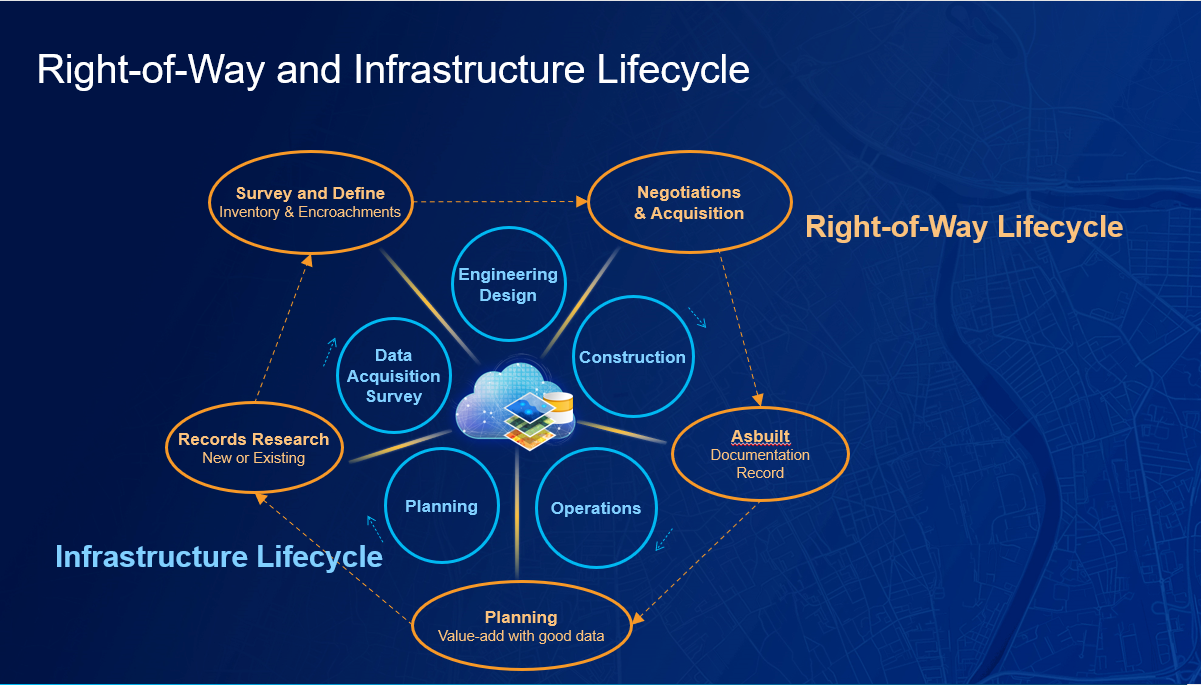
Figure A – GIS delivers value to the interdependent infrastructure and right-of-way lifecycles.
Managing an infrastructure or construction project is complicated. Part of that complication is because of the right-of-way. Where is the right-of-way? What is in the right-of-way? Who has rights in the right-of-way? Does our project fit in the right-of-way? How much does it cost to purchase additional right-of-way? Who owns the land? Are landowners supportive of our project? It’s complicated and it takes a lot of data in a holistic view to answer these and other questions. GIS provides projects with end-to-end, location-aware, project-tracking dashboards that deliver data across the project teams to help coordinate efforts and avoid excessive costs. Integrating construction management, permitting, inspection, and right-of-way status helps reduce risks and keeps projects on schedule.
Improve Planning – Working with Good Data Adds Value
It all begins with good data. Basemaps, such as satellite imagery, tax parcels, topography, existing utility networks, project files, environmental data, CAD, cultural data, existing right-of-way maps, and more are all integrated into GIS. Much of the planning data needed to begin a project is available in the Living Atlas as part of the geospatial infrastructure necessary for large projects. GIS delivers the data integration and data management requirements to visualize all data in a single view. Is this route feasible? What are the major project impediments with a particular alignment? Are there too many costly crossings? Should alternatives be considered?
When all available data is in GIS, alternatives are easily calculated and reviewed. GIS can optimize routes based on known conditions at the time. As new information is entered, new alternative routes can be calculated and analyzed. GIS helps you optimize new routes and communicate various scenarios with stakeholders and the public.
Enhance Data Acquisition, Records Research, Survey and Inventory
No two projects are the same, which also applies to what data is needed and where that data is. What tends to be an iterative process, GIS can make more efficient. GIS helps connect documents, deeds, contracts, field data, and field communications into a source of available information. Field work scheduling and reporting dashboards enable open communication with all data.
ArcGIS has configurable tools from field data collection and inventory to imagery collection and processing with drones. With smart phones and tablets, using configurable data collection applications can connect to high accuracy GNSS for precise mapping locations and can be easily set up to interview and collect landowner information. Because every project is different, the ability to easily configure tools for the project saves time, money, and eliminates duplicated field efforts.
Manage Negotiations and Real Estate Acquisition
Good public engagement is paramount for complex projects to succeed. Integrating the public record parcels and assessment data with project data helps property owners understand and negotiate right-of-way acquisition fairly. Developing and maintaining trust with landowners is critical to fair and equitable value. Delivering accurate, current project information creates transparency and fosters this relationship.
Right-of-ways cross many properties and involve many property owners. Engaging with landowners, local officials, and all stakeholders requires a two-way conversation. Using new, web-based engagement tools helps deliver current project information and enables stakeholders to subscribe to updates and provide input. Information hubs are an easy-to-configure cloud platform that organizes data and tools to accomplish specific project outreach and communication. Hubs are the center of all public outreach.
Enable Efficient Operations with Accurate As-built Data
As-built information, or the data related to what was actually constructed, is important for infrastructure management, but equally important for right-of-way information. Knowing who has what rights, how to access the right-of-way, maintenance requirements, and legal obligations among others, all benefit from well-managed information and good documentation. By laying the foundation for the future of new infrastructure that requires use of an existing right-of-way, efficiencies with planning, record research, surveying, and negotiations will benefit all.
Improve Your Right-of-Way Management with GIS
As we rethink, reimagine and rebuild our nation’s infrastructure, GIS is more important than ever. GIS plays a critical role in the entire infrastructure lifecycle from planning, surveying, design, construction, as-built documentation and ongoing operations and maintenance. This is also the case with right-of-way. GIS improves project planning by delivering integrated project and basemap data and information to all stakeholders. GIS adds new ways to collect, organize and manage ownership records, deeds, surveys, projects plans and more. GIS enables high-accuracy data collection reducing visits to the field. GIS reduces costs, strengthens public engagement and increases project efficiencies. GIS delivers a framework for better decision making.
Post Sponsor


Counties and Railroads: Shared Priorities for the Next Surface Transportation Bill
County leaders from across the country have a vital opportunity to ensure their infrastructure priorities are front and center.

Unlocking AI Starts With Strong Data Governance
Strong data governance is the foundation of trustworthy AI in government. When Agencies inventory, clean, unify and steward their data, they unlock better decisions, improved services and stronger public trust.

How County Governments Thrive with Cloud-Based Solutions
Modern cloud infrastructure enables agencies to better meet residents and workforce needs. Agencies report increased efficiencies as well as reduction of technical and operational debt as they replace aging, fragmented systems.

The Cybersecurity Health Check List: Ensure Your Cybersecurity Program is Healthy and Resilient
Many organizations neglect their cybersecurity "health," leaving them vulnerable to sudden, catastrophic cyberattacks. By following a simple cybersecurity health checklist, you can ensure your organization's cybersecurity program is healthy and resilient.

APS Expands Heat Relief Efforts in Maricopa County, Arizona
APS supports and partners with community organizations and nonprofits to provide heat relief.

Prepared to respond: How counties can strengthen readiness amid federal emergency management policy changes
As local leaders, you are often the first call - and the final line of defense - when disaster strikes. From hurricanes and wildfires to floods and winter storms, natural disasters are growing in both frequency and intensity nationwide.

#LightAPath for Amazon Deliveries This Winter
During reduced daylight hours, Amazon is encouraging customers to help drivers when they are delivering their packages in the dark.

New in 2025: Counties Should Prepare Now for the Upcoming HIPAA Security Rule Update
Counties across the country are leveraging the Sectri platform to achieve HIPAA Security Rule compliance and to proactively prepare for the updated requirements set to be finalized in 2025.

America's Opioid Crisis: Counties as Frontline Forces in the Fight
Counties serve as the first line of defense, providing essential services in public health, mental health, law enforcement and social services - supporting communities in crisis and driving lasting recovery.

Empowering Communities: How County Leaders are Tackling the Opioid Crisis Head-On
Forward-thinking county leaders are implementing year-round strategies to prevent overdoses, educate communities about the importance of proper drug disposal and connect residents with local resources for support.

County collaboration is key to overcoming the cybersecurity talent shortage
In the United States, citizens depend on county governments to deliver many of the nation’s most critical services. These organizations play a crucial role in ensuring overall community well-being by managing essential services such as law enforcement, public health, infrastructure maintenance, and emergency response.

DTE Energy bringing natural gas, opportunity to Tri-County Region in Northern Michigan
Residents of Benzie, Manistee and Wexford counties in Michigan can breathe a sigh of relief this winter as natural gas becomes available in the region for the first time leading to significant savings, increased comfort and improved reliability.

Building Resilience Against Climate Change – Insights from Tidal Basin
Carlos J. Castillo, President of Federal Services at Tidal Basin, emphasized the critical role of emergency management in local climate resilience at the 2024 NACo Legislative Conference and Annual Conference.

Investing Over $100 Billion in American Infrastructure
AT&T has invested over $140 billion in the past five years to enhance American connectivity, focusing on expanding its role as the nation's largest fiber internet provider and improving its reliable 5G network, which now serves nearly 290 million people.

Building Networks for the Next Century, Not the Last One
AT&T emphasizes its nearly 150-year history of innovation and connectivity as it transitions from traditional copper landlines to modern fiber and wireless technologies, highlighting the importance of adapting to current consumer demands and technological advancements.

Travis County Develops 2,000 Units of Housing to Address Homelessness
This post is sponsored by our partners at Guidehouse. Through Guidehouse's comprehensive support, Travis County is on track to successfully create over 2,000 units of affordable, supportive housing by 2027.

Feeding kids during the summer requires county officials
The introduction of the Summer Electronic Benefit Transfer program marks a pivotal shift in addressing childhood hunger, especially during the summer when school meals are unavailable. This nationwide initiative, offering substantial grocery benefits, promises transformative support for over 29 million children, with a significant impact on communities facing systemic inequalities.

Why customer-centric strategy is vital for digital service adoption
The importance of a customer-centric strategy in digital service adoption for county governments is emphasized, highlighting the need for thoughtful design, clear communication, and multi-channel engagement to meet user expectations and improve customer experience.

Fighting opioid addiction – one life at a time
The opioid crisis, a major national issue, saw a 55% increase in drug overdose deaths from 2019 to 2022, with 75% involving opioids. Effective strategies to combat this include integrated care, policy enhancement, and technology, focusing on whole-person care and intervention opportunities to save lives.

Planning for the post-American Rescue Plan Act future
Guidehouse outlines strategies for state and local governments to sustain programs after the end of American Rescue Plan Act (ARPA) State and Local Fiscal Recovery Funds (SLFRF) funding. It emphasizes the need for reassessing constituent needs, measuring program impact, and considering fiscal implications to ensure long-term viability and effective resource allocation for programs initially funded by SLFRF.

How voluntary benefits can help improve your employee benefit package
Voluntary benefits, tailored to diverse employee needs and often at reduced costs, are proving essential in enhancing employer benefit packages, attracting, and retaining talent, and addressing specific wellbeing issues across different age and income groups.

A countywide opioid misuse prevention campaign is easier to implement than you think
The Deterra Household Mailing Campaign delivers educational tools and deactivation pouches directly to homes. To save lives by tackling the opioid crisis.

From prevention to resilience: Strategies in wildfire mitigation
Explore a multifaceted approach to wildfire mitigation with Tidal Basin. From creating defensible spaces to early detection systems, discover strategies fostering resilient communities, protecting lives & property. Urgent action is crucial amidst rising wildfire risks. Learn more at TidalBasinGroup.com.
Related News

Research Reveals National Road Funding Crisis as County Leaders Urge Congressional Action
Research released today by the National Association of Counties (NACo) underscores a national road funding crisis and the large role counties play in the U.S. transportation network, as infrastructure investment needs outpace available revenue due to aging infrastructure, rising construction costs and weakened purchasing power. The American Society of Civil Engineers projects a $684 billion national funding shortfall for roads over the next decade, of which counties own a significant share.

House Transportation & Infrastructure Committee releases bipartisan surface transportation reauthorization bill
On May 17, the U.S. House of Representatives Committee on Transportation & Infrastructure Chairman Sam Graves (R-Mo.) and Ranking Member Rick Larsen (D-Wash.) introduced the Building Unrivaled Infrastructure and Long-term Development for America’s 250th Act (BUILD America 250 Act), a bipartisan bill that would reauthorize surface transportation programs through the U.S. Department of Transportation (USDOT) for five years. After continuous advocacy from NACo, county leaders and coalition partners, the BUILD America 250 Act contains a number of key county priorities.

NACo endorses bill to support, finance transit-oriented development projects
On April 20, NACo endorsed the Build Housing, Unlock Benefits and Services (Build HUBS) Act (H.R. 7062/S. 3636).