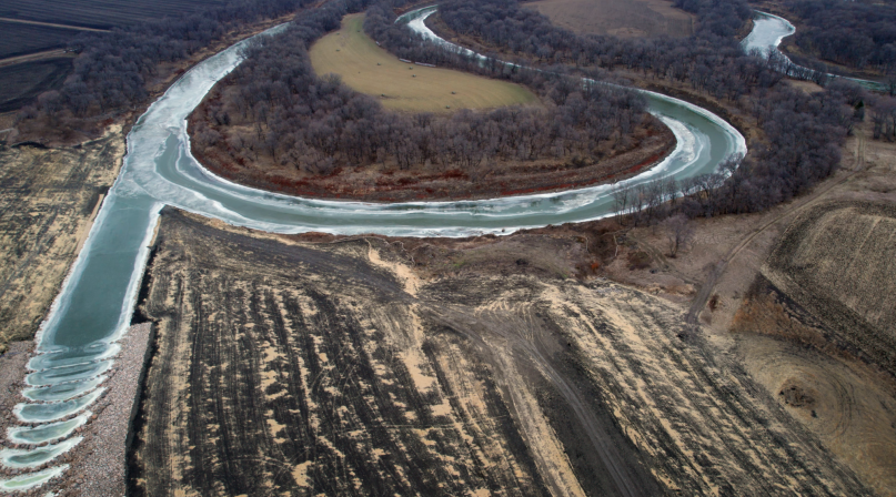
Diversion project spells relief from Fargo-area flooding

Key Takeaways
Flooding has been a part of Tony Grindberg’s life going back to his childhood in Mapleton, N.D.
“As a kid, we fought floods almost every year,” he said about his Cass County hometown. “I’d fill the gas can and man the pumps when we’d try to keep the Maple River under control.”
The Maple River feeds into the Red River, which divides North Dakota and Minnesota and flows north toward Fargo and its sister city, Moorhead, Minn., in Clay County, then on north to Grand Forks, N.D. and Canada.
In 1997, what is now the region’s second-largest flood, drove the largest evacuation of a community — 50,000 people — when Grand Forks was inundated. It was a record only broken by Hurricane Katrina in 2005. Between 2006-2011, the Red River recorded four floods that stand among the top 10 worst for the Fargo area, including the 2009 flood of record.
“All it takes is a few 60-degree days in March to rapidly thaw the snowpack,” said Jason Benson, executive director of the Metro Flood Diversion Authority (MFDA), a joint powers authority among the two counties, Moorhead, Fargo and the Cass County Joint Water Resource District. “If you add two inches of rain, you could quickly melt the snow; it would get into the river systems and cause a severe flood.”
In 2010, Cass County got the ball rolling toward a $3.2 billion flood diversion program that would circumvent high waters around 70 square miles that are home to more than 260,000 people. Voters approved a sales tax that will raise $1.2 billion through 2084. Fargo also passed a sales tax.
In 2013, Grindberg, then a North Dakota state senator, led the effort to contribute state funding to fund a flood diversion plan to help Cass County and neighboring Clay County, Minn. avoid future disasters, allocating $850 million from the state. Cass County is home to roughly a quarter of North Dakota’s residents. Minnesota added $86 million.
The federal government contributed $750 million to the project, including $437 million from the Infrastructure Investment and Jobs Act of January 2022.
Now chair of the Cass County Commission, Grindberg also chairs the Metro Flood Diversion Authority.
“I’m grateful for the opportunity to be involved,” he said. “This is a legacy project for our region, both in Minnesota and North Dakota. The real bedrock of this is the citizens assessing themselves the sales tax and their commitment not to ever have to live through a flood again.”
Construction is more than 70% complete, with a finish line less than two years away.
The process wasn’t always easy, including intensive negotiations between the governors at the time, Mark Dayton from Minnesota and Doug Burgum from North Dakota, over which state would see more disruption and impact from the projects.
For 13 years, Benson, then the Cass County engineer, served as the incident commander for flooding in the county, a role usually reserved for a county sheriff. The sheriff reported to Benson when the water rose.
Fortunately, the region has seen mild winters in the last decade-plus.
“Right now, there are a lot of people that weren’t here for the flood of 2009, 2010 or 2011,” Benson said. “People that don’t have that memory and that experience may not have voted for a sales tax that would last that long.”
The Metro Flood Diversion Authority approached the Army Corps of Engineers with the prospect of entering a public-private partnership — a first for the Corps.
“Using the public private partnership, it seemed like that was going to get things done for us a lot better than a traditional model for the Corps,” Benson said. “We could complete the project faster and cheaper.
“We didn’t have decades to get this project done.”
Where will the water go?
The Army Corps of Engineers is building the flood gates south of Fargo on the Red River and the Wild Rice River. When floodwaters reach 37 feet, the gates will close, storing water in a 20-mile embankment. Levees will protect areas developed downstream of the flood gates.
An inlet control structure will then open, releasing waters into a 30-mile diversion channel that bypasses Fargo to the west, which is being built by private contractors, until it rejoins the Red River north of Fargo. The Corps is responsible for the embankment and the inlet control structure.
The private contractors are building bridges spanning the channel they are digging: Four interstate bridges, three railroad bridges and 12 county road bridges.
“Before this, a lot of those county roads were just gravel,” Benson said. “Now all of a sudden, those 12 bridges will be among Cass County’s top 20 longest, just because of how wide this diversion channel is.”
Adding complexity to the project, two 15-foot-deep tributary rivers will cross over the diversion channel, which will range between 20 and 30 feet deep.
“We have to carry the natural river waters over top of the diversion channel, to allow for fish passage and maintaining the natural water in the river system throughout the year,” Benson said.
“During a flood, we’ll restrict the water that goes into the protected area across the aqueducts and the rest of the floodwaters will spill into the diversion channel.”
Benson noted that there are only a few similar aqueduct structures like this in the world, with natural flows over top of a man-made channel. None, however, are in a cold environment like North Dakota, so the channels will have to be heated to keep the rivers from freezing.
“It’s definitely been a great collaboration and we’ve needed that collaboration because you know, we’re working with so many different entities on both sides of the river,” Benson said.
A will and a way
As the flood diversion project nears completion, the Fargo region must survive one more winter before it can reap the benefits of the work that’s been done.
“It’s likely that all aspects of the project won’t be completely done next year, but we’ll have a channel that’s operable and the control mechanisms that control gates will be operable,” Grinberg said. “Whether or not the project is certified as operational in 2027, if we have a flood that spring, nobody’s going to stand in the way of opening their gates to protect this community.”
The diversion channels will encircle many of the rural residential areas that had been experiencing flooding.
“From a county standpoint on these really large floods, we’ll still have some of the rural flooding happen outside of the protected area, we’ll still have some roads that get washed out, but by and large, the level of impacts and the effort that the county and definitely the effort that the city of Fargo and Moorhead, Minn. will have to put in is going to be extremely small compared to what we had to do in the past,” Benson said.
That will likely be the end of Cass County’s prolific sandbag production process. For decades, they were the region’s last line of defense against floodwaters.
When the call goes out, volunteers converge on the Fargodome and have been able to fill 250,000 bags in a day, which is what some of the eastern North Dakota floods have called for. Local high school students are held in reserve to be the muscle that places the sandbags on the levees.
“We were filling 300,000 sandbags for some floods and now it will be down to a few thousand,” said Cass County Manager Robert Wilson.
The project’s completion will mark an era of security and stability for the growing region. In addition to agriculture, kept fertile by the Red River, industrial and commercial projects have fueled consistent population growth.
“We’ve got some very large businesses in our community and we’re driving economic growth for the region, but soon, we won’t have to worry about losing huge chunks of the town from a flood,” Benson said.
Grinberg said the investment that residents make through the sales tax that is funding the project will come back to them.
“Residents here are paying something close to $60 million annually in flood insurance premiums to protect their homes,” he said.
“If we can remove the threat of flood, that’s close to $60 million that will remain in our local economy.”
Related News

States file lawsuit challenging FEMA’s new rules on emergency management grants
On November 4, a coalition of 12 states filed a lawsuit against the U.S. Department of Homeland Security (DHS) and the Federal Emergency Management Agency (FEMA), alleging that recent changes to key emergency management grants are unlawful and could disrupt state and local preparedness efforts.

County Countdown – Nov. 4, 2025
Every other week, NACo's County Countdown reviews top federal policy advocacy items with an eye towards counties and the intergovernmental partnership.
FEMA bill staffers offer insights into reform effort
NACo Intergovernmental Disaster Reform Task Force heard from staffers who helped shape a bill that would make dramatic changes to the Federal Emergency Management Agency.
County News
More than a pipe dream: Harris County hopes for flooding relief

