Slow-moving landslide gives Yakima County, Wash. time to plan

Yakima County, Wash. has been planning for months for a massive landslide that is bound to happen. It's just a matter of when.
Not every natural disaster comes with a two-month notice, so Yakima County, Wash. is counting its blessings.
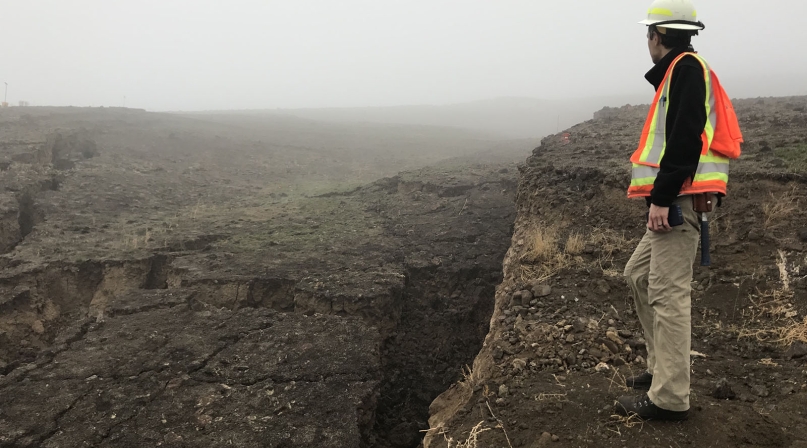
For several months, roughly 20 acres of a hillside — Rattlesnake Ridge — has been sliding away, threatening homes, highways and the Yakima River. In recent weeks, the slide’s acceleration has slowed, muddying predictions as to when it will all fall down.
“It’s unique that it gives us time to plan and coordinate, it’s almost like planning for an event,” said Yakima County Emergency Management Director Jeff Emmons. “It’s given us plenty of time to coordinate and form relationships in advance.”
A striking crack in the hillside, first visible from an airplane, has loomed large over the county since October. A brush fire during the summer cleared vegetation and revealed the crack, alerting officials to the situation a few months earlier than they otherwise would have.
More than 50 different agencies have combined forces in response to the situation, primarily county, state and tribal governments and private contractors. The hillside is all private, owned by the Yakima Nation and a quarry.
Prediction models show the hillside, roughly 4 million cubic yards of material, traveling south, into the quarry’s gravel pit and a trailer park, where 70 people lived, before reaching a county road and then Interstate 82.
“The hillside was moving at about 1.7 feet per week, but it recently slowed to 1.6 feet per week,” said Joe Smillie, a state Department of Natural Resources (DNR) spokesman. “That’s made it a little harder to predict how it will move, and when the hill will fail.”
When the slide was first noticed in October, it was moving at a rate of 1 foot per month.
Earlier projections showed the hillside coming down in March 2018, but its slowdown has prompted observers to push that prediction back.
Smillie said roughly five layers of volcanic basalt has sandwiched soil, and the sandwiched layers are sloping downhill. The state DNR said water doesn’t seem to be a factor, and an investigation into the cause of the slide will not be launched while agencies are focused on emergency preparation. KIRO News in Washington reported that aerial photographs dating back to the 1970s show a crack along the hillside, albeit much smaller than it is currently.
After a pilot informed the county about the crack, the county contacted the quarry owners, who hired a geology firm, and the county issued evacuation notices for residents south of the landslide.
“There were challenges for where they’d go, many of them were low-income, so it took two weeks to work through those challenges, but the quarry operators stepped up and paid for five weeks in hotels for residents who had nowhere else to go,” Emmons said.
All residents in the path of the slide are renters. County social services are working on long-term solutions for the families. It’s not apparent if, when the landslide is finished, their homes will be damaged.
“We have three scenarios, the most likely being that the landslide will stop at the quarry, but we’re also concerned it will reach the homes and the roads,” Emmons said. “There’s a chance it could reach the river.”
The state Department of Transportation has placed barriers into the projected path, in hopes of stopping material from reaching the roads.
For the county, Emmons said the challenge has been public messaging.
“It’s very technical, so it took a while to get the visuals out, makes it harder for public to visualize, wrap their head around,” he said. “We don’t know how long it’s going to take, and that keeps people on edge.”
In the meantime, half-hour measurements monitor changes in the rate of the landslide.
Smillie said the whole situation has been novel.
“Usually when you do landslide studies, it’s after the land has slid and you’re doing a post mortem,” he said. “From a wonky science standpoint it’s interesting to have all of this time to study it before it happens. From a public safety standpoint, we’re able to get out ahead of it.”
Attachments
Related News

White House launches federal flood standard support website and tool
On April 11, the White House launched a new website and mapping tool to help users with the ongoing implementation of the Federal Flood Risk Management Standard (FFRMS).

As disasters increase, counties must invest in mitigation
Disasters are becoming more frequent, more severe and more costly, and counties, parishes and boroughs are on the front lines — where the immediate response is handled and where the personal impact is felt.

Micro-grants help fireproof a neighborhood by reducing fuel
Nevada County, Calif. helped communities reduce the vegetation that could easily spread fire in neighborhoods.
